Google Introduces Traffic Info to Maps
Google has added traffic status information to select cities on Google Maps. This is the first substantial Google Maps update in quite some time and it seems as though Google is playing a bit of catch-up with Yahoo! Maps. Yahoo’s mapping service has displayed live traffic information for quite some time already.
Regardless, I welcome the new feature.

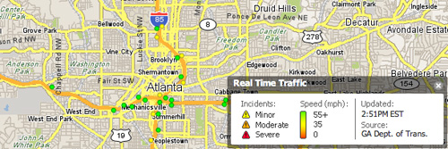
Google Maps Traffic Info

Yahoo! Maps Traffic Info
For more than 30 major U.S. cities, you can now see up-to-date traffic conditions to help you plan your schedule and route. If you’re in San Francisco, New York , Chicago, Dallas, or any of the other cities we now include, just click on the traffic button to show current traffic speeds directly on the map. If your route shows red, you’re looking at a stop-and-go commute; yellow, you could be a little late for dinner; green, you’ve got smooth sailing.


Very nice. I think I like Googles integrations of the traffic info better…though I tend to prefer the Yahoo UI for maps.
Very nice!
Yes, finally. Although it has been in their mobile version (at least for Palm OS) for a while now, it’s nice to see traffic added to the web interface.
Would be nice to see them expand this feature. There are no Canadian cities on the list yet.
Is it me or is there no information provided except for colored roads? What’s the difference between gray and green roads?
gray means there’s no traffic info available, green means speeds 50mph or greater, red is under 25mph and yellow is in between, IRC.
This is perfect for the iPhone
It’s about time, that was the only thing I used Yahoo Maps for…
I can’t wait until they actually integrate Canadian cities into that list. I’d love to see traffic results for Montreal and Calgary.
I’ve been getting this this on Google Maps for Mobile on my Blackberry for the last month (that’s when I got the Blackberry)…and yup….the 2 times I was stuck in traffic, it was red.
It’s okay but there’s something better for us in the UK, in the form of http://www.trafficeye.co.uk. It contains real-time info on accidents, congestion etc.. and it should be evolving into a mobile app soon
now if only it will tell you which is the fastest way to get to school during rush-hour in LA.