Twitter: at the college of computing backing up a database on a CC server.. i think i spotted [...]

Flickr To Add Geo Tagging

Aug 28, 2006 in , , ,

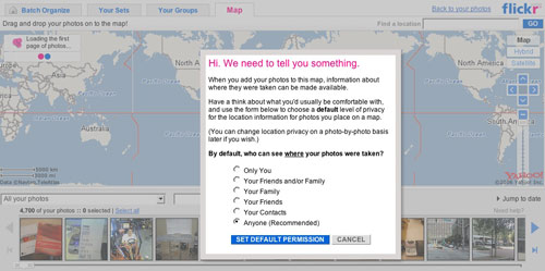
Kudos to the Flickr folks at Yahoo! as they will be rolling out geo tagging functionality later today as noted on TechCrunch. Utilizing Yahoo! Maps and Yahoo! Search technology, the new flickr feature will bring an updated Organizr which allows you to tag your photos and photosets by simply marking them on a Yahoo! Map. In addition, you will be able to search for photos by location which should come in handy if you want to scope out a new city or college campus.

Currently it seems as though all geo tagging is manual and you must do it on a per photo or per photoset basis. Hopefully in the near future when digital cameras come equipped with GPS data loggers, Flickr will be able to extract the new EXIF image data that might carry longitude and latitude coordinates.

Flickr Geo Tagging
Flickr Geo Tagging
Flickr Geo Tagging 3
Promote this article on various sites or email to your friends:     


15 Comments

  1. It’s working!
    :-)

  2. If Geo Tagging would be automatic, that would be just flipping sweet. Doing things manually for anything is always a pain, and it usually never gets done.

  3. Actually, judging by the comments in the forum thread, they ARE auto-importing images already tagged with location information.

  4. Looks awesome, I tried geotagging before with ZooomR but I use flickr way more frequently :)

  5. GPS-enabled cameras. I can’t wait ’till that day comes.

  6. Wow I never knew Flickr was going to roll out this feature. Going to try it out now :) Thanks for letting us know!

  7. I spent WAY too much time dragging images on to the map. So unproductive, yet so damn entertaining and addictive!

  8. We already can extract the EXIF location info, you just need to turn it on first here…

    http://www.flickr.com/account/geo/exif

    …and wait for camera manufacturers to catch up to of course. Then it’ll be as simple as point, shoot and upload.

  9. I’m one of the guys behind Panoramio, a community of geotagged photos. Panoramio includes a drag and drop geotagging interface to locate your photos over Google Maps. Photos with geodata in EXIF are automatically located in Panoramio. You also can watch the photos in Google Earth through KML feeds.

    Already 38.000 photos have been geotagged in Panoramio. I would like to hear your opinión about our site.

    Regards,

    Eduardo

  10. Sweet! I’m glad that Yahoo! has updated their maps to something that is actually usable. I got spoiled when Google came out with the click and drag maps years ago and haven’t used Mapquest/Yahoo ever since. Now I can quit complaining to my wife when she goes to Yahoo! to find directions.

  11. that is way cool, i just downloaded google earth today, and was imagining walking through the earth at the speed of “sound” (namely a click)… and viewing the world through peoples lenses and experience..

    talk abpout being omnipotent!

  12. Min, I’m glad you like Panoramio’s KML feed for Google Earth.

    http://www.panoramio.com/panoramio.kml

    I like very much your way of explaining it:

    “…viewing the world through peoples lenses and experience”

    Maybe we take it like a tagline for Panoramio ;)

    Thanks

    Eduardo

  1. [...] Paul‘un ve TechCrunch‘un konu hakkındaki yazılarını okur okumaz hemen Flickr blogunu kontrol ettim ve gün içerisinde Geo Tagging özelliÄŸi ekleyeceÄŸini duyurdukları Flickr’ın söz konusu özelliÄŸi hayat geçirdiÄŸini gördüm, sanırım geç kalmışım :) [...]

Post a comment, receive Stammy points.


Send a trackback.


  • If you plan on posting code, run it through Postable first.
Copyright © 2005 - 2008 PaulStamatiou.com  Privacy Policy - Terms of Service Can't spell my name? Use PSTAM.com. Go back up ↑.